|
|
|
|
|
|
|
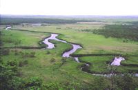
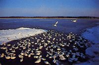
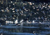
Municipalities Involved: Kushiro City, Kushiro Town, Shibecha Town, Tsurui Village, Hokkaido Prefecture, Major Type of Wetland: Peat Bog, Freshwater Lakes and Ponds, Rivers and Streams Altitude: 3-10 meters Area: 7,863 hectares Ramsar Designation: 17 June 1980 |
|
|
|||
|
|
|
||
|
|
||
|
|
|
|
|
|
|
|
|
|
|
Web Site: Kiritappu-shitsugen Center |
|
|
|
|
|
|
|
Utonai-ko |
|
|
Izu-numa and Uchi-numa |
|
|
Sakata |
|
|
Yatsu-higata |
|

|
Katano-kamoike |
|
|
Biwa-ko |
|
| Man-ko Municipalities Involved: Tomigusuku Village, Naha City, Okinawa Prefecuture Type of Wetland: Inland Rivermouth Lake, Rivermouth tidal flat, Manrove Swamp Altitude: 0.5 meters below sea level Area: 58 hectares Ramsar Designation: 15 May 1999 |
|
| Fujimae-higata Municipalities Involved: Nagoya City, Aichi Prefecuture Area: 323 hectare Ramsar Designation: 2 November 2002 |
|
| Miyajima-numa Municipalities Involved: Bibai City, Hokkaido Prefecuture Area: 41 hectares Ramsar Designation: 2 November 2002 |
|
| Akiyoshidai Groundwater System Municipalities Involved: Miho City, Yamaguchi Prefecture Type of Wetland: Groundwater Systems, Karst Altitude: 80-425.5m Area: 563 hectares Ramsar Designation: 8 November 2005 |
|
| Furen-ko and Shunkuni-tai Municipalities Involved: Nemuro City and Betsukai Town, Hokkaido Prefecture Type of Wetland: Brackish lakes, Seagrass/seaweed beds, Sandbars, Low moors, Tidal flats Altitude: 1m Area: 6,139 hectares Ramsar Designation: 8 November 2005 |
| Hotokenuma Municipalities Involved: Misawa City, Aomori Prefecture Type of Wetland: Low moors Altitude: 0-10m Area: 222 hectares Ramsar Designation: 8 November 2005 |
|
| Imuta-ike Municipalities Involved: Satsumasendai City, Kagoshima Prefecture Type of Wetland: Freshwater lake(Crater lake) Altitude: 296m Area: 60 hectares Ramsar Designation: 8 November 2005 |
|
| Kabukuri-numa and the surrounding rice paddies Municipalities Involved: Kurihara City, Tome City and Osaki City, Miyagi Prefecture Type of Wetland: Freshwater lake(dammed lake), Low moor, Rice paddies Altitude: 5.7m Area: 423hectares Ramsar Designation: 8 November 2005 |
| Kerama-shoto Coral Reef Municipalities Involved: Zamami Village and Tokashiki Village, Okinawa Prefecture Type of Wetland: Coral reefs Altitude: 0m Area: 353hectares Ramsar Designation: 8 November 2005 |
| Kuju Bogatsuru and Tadewara-shitsugen Municipalities Involved: Kokonoe Town and Takeda City, Oita Prefecture Type of Wetland: Intermediate moors Altitude: 1,230-1270m(Bogatsuru), 1,000-1,040m(Tadewara) Area: 91hectares Ramsar Designation: 8 November 2005 |
|
| Kushimoto Coral Communities Municipalities Involved: Kushimoto Town, Wakayama Prefecture Type of Wetland: High-latitude Coral Communitites Altitude: -20-0m Area: 574hectares Ramsar Designation: 8 November 2005 |
|
| Mikata-goko Municipalities Involved: Wakasa Town and Mihama Town, Fukui Prefecture Type of Wetland: Brackish lakes Altitude: 0m Area: 1,110hectares Ramsar Designation: 8 November 2005 |
|
| Nagura Amparu Municipalities Involved: Ishigaki City, Okinawa Prefecture Type of Wetland: Tidal flats, Mangrove forests Altitude: 0m Area: 157hectares Ramsar Designation: 8 November 2005 |
|
| Nakaumi Municipalities Involved: Yonago City and Sakaiminato City, Tottori Pref.; Matsue City, Yasugi City and Higashiizumo Town, Shimane Pref. Type of Wetland: Brackish Lake Altitude: 0m Area: 8,043hectares Ramsar Designation: 8 November 2005 |
|
| Notsuke-hanto and Notsuke-wan Municipalities Involved: Betsukai Town and Shibetsu Town, Hokkaido Prefecture Type of Wetland: Shallow marine waters, Tidal flats, Seagreen/seaweed beds, Salt marshes, Low moors, Sand spits Altitude: 0-10m Area: 6,053hectares Ramsar Designation: 8 November 2005 |
|
| Oku-Nikko-Shitsugen Municipalities Involved: Nikko City, Tochigi Prefecture Type of Wetland: High moors, Internediate moors, Freshwater lakes Altitude: 1475m(Yuno-ko), 1400m(Senjogahara), 1410m(Odashirogahara) Area: 260.41hectares Ramsar Designation: 8 November 2005 |
|
| Oze Municipalities Involved: Hinoemata Village, Fukushima Pref.; Uonuma City, Niigata Pref.; Katashina Village, Gunma Pref. Type of Wetland: High moors, Freshwater lakes Altitude: 1400-1420m(Marshland area), 2356m(highest point) Area: 8,711hectares Ramsar Designation: 8 November 2005 |
|
| Sarobetsu-genya Municipalities Involved: Horonobe Town and Toyotomi Town, Hokkaido Prefecture Type of Wetland: High moors, Intermediate moors, Low moors, Freshwater lakes Altitude: 3-7m Area: 2,560hectares Ramsar Designation: 8 November 2005 |
| Shinji-ko Municipalities Involved: Matsue City, Izumo City and Hikawa Town, Shimane Prefecture Type of Wetland: Brackish lake Altitude: 0.3m Area: 7,652hectares Ramsar Designation: 8 November 2005 |
| Tofutsu-ko Municipalities Involved: Abashiri City and Koshimizu Town, Hokkaido Prefecture Type of Wetland: Brackish lakes Altitude: 1m Area: 900hectares Ramsar Designation: 8 November 2005 |
| Uryunuma-shitsugen Municipalities Involved: Uryu Town, Hokkaido Prefecture Type of Wetland: High moors Altitude: 850-900m Area: 624hectares Ramsar Designation: 8 November 2005 |
|
| Yakushima Nagata-hama Municipalities Involved: Yakushima Town, Kagoshima Prefecture Type of Wetland: Sand shore Altitude: below 10m Area: 10hectares Ramsar Designation: 8 November 2005 |
|
| Oyama Kami-ike and Shimo-ike Municipalities Involved: Tsuruoka City, Yamagata Prefecture Type of Wetland: Freshwater lakes Altitude: 12m Area: 39hectares Ramsar Designation: 30 October 2008 |
|
| Hyo-ko Municipalities Involved: Agano City, Niigata Prefecture Type of Wetland: Water storage area Altitude: 8.6m Area: 24hectares Ramsar Designation: 30 October 2008 |
|
| Kejo-numa Municipalities Involved: Osaki City, Miyagi Prefecture Type of Wetland: Water storage area Altitude: 25.9m Area: 34hectares Ramsar Designation: 30 October 2008 |
|
| Streams in Kume-jima Municipalities Involved: Kumejima Town, Okinawa Prefecture Type of Wetland: Streams Altitude: 120-280m Area: 255hectares Ramsar Designation: 30 October 2008 |
|
| Arao-higata Municipalities Involved: Arao City, Kumamoto Prefecture Type of Wetland: Tidal flat Altitude: 0m Area: 754 ha Ramsar Designation: 3 July, 2012 |
|
| Lower Maruyama River and the surrounding rice paddies Municipalities Involved: Toyooka City, Hyogo Prefecture Type of Wetland: River, Rice paddies Altitude: 0-20m Area: 560hectares Ramsar Designation: 3 July 2012 |
|
| Miyajima Municipalities: Hatsukaichi City, Hiroshima Prefecture Type of Wetland: Sandy shore, Intertidal marsh and river Altitude: 0-2 m Area: 142 hectares Ramsar Designation: 3 July, 2012 |
|
| Onuma Municipalities: Nanae Town, Hokkaido Prefecture Type of Wetland: Freshwater lake Altitude: 130m Area: 1,236 hectares Ramsar Designation: 3 July, 2012 |
|
| Tateyama Midagahara and Dainichidaira Municipalities: Teteyama Town, Toyama Prefecture Type of Wetland: Snow patch grassland Altitude: 1040-2120m Area: 574 hectares Ramsar Designation: 3 July, 2012 |
|
| Tokai Hilly Land Spring-fed Mires Municipalities: Toyota City, Aichi Prefecture Type of Wetland: Oligotrophic spring-fed mire Altitude: 111-254m Area: 22 hectares Ramsar Designation: 3 July, 2012 |
|
| Watarase-yusuichi Municipalities: Furukawa City in Ibaraki Prefecture, Tochigi City, Oyama City and Nogi Town in Tochigi Prefecture, Itakura Town in Gunma Prefecture and Kazo City in Saitama Prefecture Type of Wetland: Low moor Altitude: 8-23 m Area: 2,861 hectares Ramsar Designation: 3 July, 2012 |
|
| Yonahawan Municipalities: Miyako City, Okinawa Prefecture Type of Wetland: Tidal flat Altitude: 0m Area: 704 hectares Ramsar Designation: 3 July, 2012 |
|
![]()